


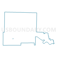
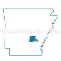
P41 Voting District, Jefferson County, Arkansas
About
Outline

Summary
| Unique Area Identifier | 526900 |
| Name | P41 Voting District |
| County | Jefferson County |
| State | Arkansas |
| Area (square miles) | 0.07 |
| Land Area (square miles) | 0.07 |
| Water Area (square miles) | 0.00 |
| % of Land Area | 100.00 |
| % of Water Area | 0.00 |
| Latitude of the Internal Point | 34.14804730 |
| Longtitude of the Internal Point | -92.07705690 |
Maps

Graphs
Select a template below for downloading or customizing gragh for P41 Voting District, Jefferson County, Arkansas


Neighbors
Neighoring Voting District (by Name) Neighboring Voting District on the Map
- 36 Voting District, Jefferson County, AR
- 42 Voting District, Jefferson County, AR
- P22 Voting District, Jefferson County, AR
- P39 Voting District, Jefferson County, AR
- P40 Voting District, Jefferson County, AR
Top 10 Neighboring County Subdivision (by Population) Neighboring County Subdivision on the Map
- Spring township, Jefferson County, AR (2,751)
- Niven township, Jefferson County, AR (1,682)
- Talladega township, Jefferson County, AR (1,267)